 Today we have a guest post from Mitch Stevens, who runs a terrific Tucson-based company called Southwest Discoveries, which specializes in hiking tours in Arizona and elsewhere in the Southwest.
This is the first post in a series that Mitch has written about “Hiking the Escalante,” showcasing the beauty and splendor of the awe-inspiring formations created by the Escalante River in southern Utah. It will give you a good sense of hiking Coyote Gulch, what Mitch calls the “most beautiful hike in the Southwest.” (And that’s saying a lot.)
Not incidentally, Mitch welcomes — encourages — baby boomers to join his hiking tours. This one is for active, fit boomers who enjoy the best that nature has to offer.
By Mitch Stevens
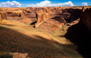
Sheer cliffs, red rock walls, ancient geologic sculptures and dozens of tributaries await the adventurous trekker when hiking Coyote Gulch; a stunning, nine-mile side drainage of the Escalante River set in the heart of southern Utah’s rugged canyon lands.
This immense untrammeled land was a place of stunning side canyons, geology, and botany, light and shadow, with delicate maidenhair fern and grass set against the backdrop of the cool, glistening Colorado River.
A place of glowing red Navajo and Wingate Sandstone, the geology ranges from razor-sharp cliffs, cascading terraces and uplifted arches, to twisted strata dressed in black desert varnish. Blues, yellows, oranges and purples completed the color spectrum; rich, dramatic and magnificent.
Open to the sky, the sheer cliffs of Coyote Gulch are continuously altered by sun, rain, wind and snow. Deep within these stony estates, calm and quiet reign.Coyote Gulch is a small slice of paradise, reminiscent of the old Glen Canyon before it was ruined by the rising waters of Lake Powell 53 years ago.
The Hike Begins
Our group of eight fellow hikers headed into the Escalante Grand Staircase National Monument last April for not only the awe-inspiring scenery but mild temperatures, wildflowers, and spring-green vegetation.
 We entered the canyon via “Crack in the Wall,” 36 miles south of U.S. 12, off Escalante Grand Staircase’s Hole in the Rock Road. To access this hike, we turned left at Forty Mile Ridge Road and followed it for 4.3 miles to the trailhead.
After an easy two miles, we reached the rim of the canyon. From this vantage point, it seemed impossible to make it to the canyon floor safely. The “crack” in the wall is exactly that, a crack. We lowered our packs down the rock wall, tied on to a 30-foot rope.
Our group, one by one, squeezed through a space about 18 inches wide to overcome this obstacle. We descended a huge red sand dune to reach the canyon bottom, a hike which featured exhilarating views of sculpted red sandstone cliffs and the gigantic Stevens Arch in the distance.
Once at the bottom of Coyote Gulch, we were impressed by just how small we felt and how tall the canyon walls really were. After exploring Stevens Arch, we set up camp underneath a huge grand alcove. Our campsite featured high ceilings overhead and views across the river of soaring canyon cliffs, chiseled by wind, ice, rain, and elements of the ages.
Day Two
Next morning, we backpacked upstream, in the opposite direction from the Escalante River. Coyote Creek flows from west to east, down to the Escalante River. Many members in our group, including yours truly, couldn’t resist the urge of clicking photos every couple of steps. The scenery along this stretch of the creek was truly breathtaking.
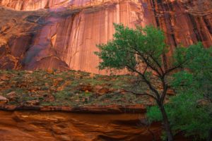
There were a surprising number of trees and brilliant green vegetation down in the canyon floor which made for an outstanding contrast from the glowing red sandstone. Under our feet, the lively stream chiseled and coursed through the relatively hard Kayenta Formation, forming dazzling waterfalls. We splashed through the creek and located trails which safely bypassed the cascades. Later on, we came upon a particularly scenic chute and waterfall which provided a refreshing mid-day swim in the warm April sun.
We hiked for three hours that morning to reach one of three spectacular natural arches, Coyote Natural Bridge. But before we walked under this amazing landmark, off our right shoulders stood the obscure and wonderful Cliff Arch. This slender and graceful stone arch plunged from the top of a huge rock wall to the canyon bottom.
During our journey while hiking Coyote Gulch, we observed water seeps along the walls near stream level. We stopped at a few of the more vigorous springs to refresh our water containers. The quality of the water at these fountains pouring out of the rocks, was superb and quite refreshing, one of the many delights of this canyon.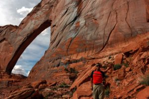
On to the Black Lagoon
We headed north at a small tributary of Coyote Creek, dropped our packs, and hiked a half a mile along a clear stream which fed the remarkable Black Lagoon. We listened to the tranquil sounds of dripping water which seeped from the ceiling of the overhang into the lake. The pond curved out of sight to the right, hidden and encased among the red slick-stone.
This place, lush vegetation, wildflowers, silence, soaring red cliffs reflected in the clear water, tranquility, represented the true essence of our journey and is one of the great experiences when hiking Coyote Gulch. We lingered there a while and enjoyed our lunch break.
When our group rejoined the main watercourse, the canyon continued to bend and snake dramatically; we observed huge amphitheaters deeply overhung and streaked with desert varnish which gave us a good indication of vertical.
Late in the afternoon, we reached Jacob Hamblin Arch, which rose majestically over the creek. We camped at the foot of the arch, named one of the best campsites in North America by Backpacker Magazine.
The next day, we hiked another glorious mile and a half to Hurricane Wash, one of three main exit points you can use when hiking Coyote Gulch.
Before doing so, we explored yet another immense cathedral-like recess on the opposite side of the stream. A spring-fed creek emerged out of a mysterious place deep within the rocks and created its own magic before spilling into the main stream course. If we had more time, we would have explored this side drainage further.
Instead, we backtracked to Hurricane Wash and walked five miles up the mostly dry drainage to the trailhead and our vehicles, capping a memorable three-day sojourn at one of the most beautiful places in the entire Southwest.


![]() Follow me on Twitter
Follow me on Twitter
![]() Connect on Facebook
Connect on Facebook
![]() Amazon Author page
Amazon Author page
![]() Connect on LinkedIn
Connect on LinkedIn


Get My Latest Report for FREE:

Click to download: How to Ride the Coming Wave of Boomers ... And Attract the Biggest-Spending Travelers the World Has Ever Seen!
- The Perils and Pleasures of Navigating a French Canal
- How to Add Fun to Business Travel
- Where to Find the Real St. Patrick
- “Stunning! Breathtaking!”: The Chatbot’s Guide to Portugal
- Traveling with a Disability? Here are 5 Tips
- Going to Malta? Here are 3 places to visit
- Are Your Medicines Illegal Overseas?
- Why You May Have Skipped Summer Travels
- Congratulations — You’ve Earned Five Stars!
- 7 Travel Scams — and How to Avoid them

Leave a Reply